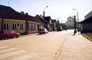
Home

Shtetl Life

Holocaust Landsmanshaftn

History

Photos Yizkor Book
Maps Trips Surnames Researchers Links Guest Book

Contact


Picture Gallery of Mike Marvins' Trip to Szczuczyn, 2001

Comparing Current Photos to Old Ones


Town Square: Goes from Market Square (on right) north toward Grajewo.
Kaplan Photography Studio and Synagogue were further out this street.
City government buildings are on top right of Square. Square used to be paved.
This is the same shot as the 1920's Market Square photo with all the people and wagons in the Square.
(Photo courtesy of Michael H. Marvins)


Church Street:
This area was a mixed
Jewish/Polish neighborhood until WWII

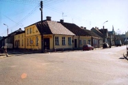
Corner of Market Square and Church St.:
Large building on left, one of the oldest
in Szczuczyn, which used to be a tavern,
is now an Office Depot.

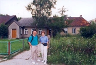
Kaplan Studio and home (1995):
Now divided into 3 apartments
 
Kilinskiego Street:
Taken in front of Kaplan home looking north.
Building on left is probably the Okuniewski brewery and home.
The Russians invaded Szczuczyn in 1920 down this street.

Modern welcome sign to Szczuczyn:
Includes town map; Layout of the town hasn't
changed hasn't changed since the 1600's
 

Photos courtesy of Michael H. Marvins, 2001


Compare how the same
areas used to look:


Church Street

Church Street

Kaplan Studio
 
Kilinskiego Street

Town Sign
 
 
   Return to Photos, Return to Trips